Landsat 7 and ETM+ Characteristics

Band Number Spectral Range(microns) Ground Resolution(m)
1 0.45 - 0.515 30
2 0.525 - 0.605 30
3 0.63 - 0.690 30
4 0.75 - 0.90 30
5 1.55 - 1.75 30
6 10.40 - 12.5 60
7 2.09 - 2.35 30
Pan 0.52 - 0.90 15


Swath width: 185 kilometers
Repeat coverage interval: 16 days (233 orbits)
Altitude: 705 kilometers
Quantization: Best 8 of 9 bits
On-board data storage: ~375 Gb (solid state)
Inclination: Sun-synchronous, 98.2 degrees
Equatorial crossing: Descending node; 10:00am +/- 15 min.
Launch vehicle: Delta II
Launch date: April 1999


References:
NASA, Supplying data users worldwide with low cost, multi-purpose, land remote sensing data into the next century

Scan Line Corrector Failure (SLC Off)

ETM+ Scan Line Correction Graphic

On May 31, 2003 the Scan Line Corrector (SLC) in the ETM+ instrument failed. The SLC consists of a pair of small mirrors that rotate about an axis in tandem with the motion of the main ETM+ scan mirror. The purpose of the SLC is to compensate for the forward motion (along-track) of the spacecraft so that the resulting scans are aligned parallel to each other. Without the effects of the SLC, the instrument images the Earth in a "zig-zag" fashion, resulting in some areas that are imaged twice and others that are not imaged at all. The net effect is that approximately one-fourth of the data in a Landsat 7 scene is missing when acquired without a functional SLC.

Following the SLC failure, an Anomaly Response Team (ART) was assembled, consisting of representatives from the USGS, NASA, and Hughes Santa Barbara Remote Sensing (the manufacturer of the ETM+ instrument). The team assembled a list of possible failure scenarios, most of which pointed at a mechanical problem with the SLC itself. Since there is no backup SLC, a mechanical failure would indicate that the problem was permanent. However, the team was unable to rule out the possibility of an electrical failure, though such a possibility was deemed remote. Nevertheless, on September 3, 2003, USGS director Charles G. Groat authorized the Landsat project to reconfigure the ETM+ instrument and various other subsystems on board Landsat 7 to use the spacecraft's redundant ("Side-B") electrical harness.

With this authorization, the USGS flight operations team at the NASA Goddard Space Flight Center uploaded a series of commands to the spacecraft, instructing it to operate using the redundant electrical harness. This operation was successful, and on September 5, 2003, the ETM+ instrument was turned on and acquired data that was sent to the Landsat ground system at EROS outside of Sioux Falls, South Dakota. It was immediately apparent that the migration to the Side-B electrical harness had not fixed the problem with the SLC. Following this, the instrument was reconfigured to use its primary electrical harness. The subsequent conclusion of the ART was that the SLC problem was mechanical and permament in nature.

Landsat 7 continues to acquire data in this mode. Data products are available with the missing data optionally filled in using other Landsat 7 data selected by the user. To continue the Landsat legacy, studies are underway to fly an equivalent scientific sensor on a new satellite towards the end of this decade.


References:
- Wikipedia, Landsat 7.
- NASA Landsat Handbook,
ETM+ Scan Line Corrector.

Major Benefits of Landsat 7

1. Mission Continuity: Landsat 7 is the latest in a long history of land remote sensing spacecraft, spanning 33 years of multispectral imaging of the Earth's surface, starting with the launch of Landsat 1 in 1972. In particular, the ETM+ continues the database of Earth imagery begun in 1982 by the Landsat 4 Thematic Mapper, providing the same spectral bands for consistent change detection.

2. Global Survey Mission: Landsat 7 data is acquired systematically to build and periodically refresh a global archive of sun-lit, substantially cloud-free images of the Earth's landmass. Approximately one quarter of the Earth's landmass is imaged every 16 days, using a planning scenario that emphasizes seasonal changes in vegetation and uses cloud predictions from NOAA to avoid imaging cloudy areas, thus optimizing the data acquisition strategy. If the data user wants a particular image, chances are that it is already in the data archive. Also, as environmental changes occur on the Earth's surface, it is highly probable that recent prior data already exists and can be quickly retrieved to compare with newly acquired data.

3. Affordable Data Products: Landsat 7 data products are available from the USGS Center for Earth Resources Observation and Science (EROS), Sioux Falls, South Dakota. These products are distributed at "the Cost of Fulfilling User Requests", known as the COFUR price. This is a significant price reduction from commercial data sales, allowing renewed use of Landsat data in academic institutions for scientific research. This has again stimulated the use of multispectral imagery in a variety of applications, fostering new uses not only for Landsat data but for other remote sensing data as well.

4. Absolute Calibration: Landsat 7 data from the ETM+ is calibrated to better than 5%, and serves as an on-orbit standard for cross-calibration of other Earth remote sensing missions. NASA orbited the EOS-AM1 spacecraft and EO-1 in formation with Landsat 7 to take advantage of this enhanced calibration.

These features, combined with all the traditional utility of Landsat data proven over 33 years, makes Landsat 7 data important for a wide and diverse remote sensing community.


References:
- NASA, Landsat 7.

Landsat 7

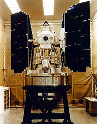
Landsat 7 being prepared for launch.
Launch
Date April 15, 1999
Vehicle Delta II
Site Vandenberg AFB
Orbit characteristics
Reference system WRS-2
Type Sun-synchronous, near-polar
Altitude 705 km (438 mi)
Inclination 98.2°
Repeat cycle 16 days
Swath width 185 km (115 mi)
Equatorial
crossing time
10:00 AM +/- 15 minutes


History of Landsat 7

The government-owned Landsat 7 was successfully launched on April 15, 1999 from the Western Test Range of Vandenberg Air Force Base, California, on a Delta-II expendable launch vehicle. The Earth observing instrument on Landsat 7, the Enhanced Thematic Mapper Plus (ETM+), replicates the capabilities of the highly successful Thematic Mapper instruments on Landsats 4 and 5.

The ETM+ also includes additional features that make it a more versatile and efficient instrument for global change studies, land cover monitoring and assessment, and large area mapping than its design forebears.

These features are:

  • a panchromatic band with 15m spatial resolution
  • on-board, full aperture, 5% absolute radiometric calibration
  • a thermal IR channel with 60m spatial resolution
  • an on-board data recorder

Landsat 7 is the most accurately calibrated Earth-observing satellite, i.e., its measurements are extremely accurate when compared to the same measurements made on the ground. Landsat 7’s sensor has been called “the most stable, best characterized Earth observation instrument ever placed in orbit.” Landsat 7’s rigorous calibration standards have made it the validation choice for many coarse-resolution sensors.

The excellent data quality, consistent global archiving scheme, and reduced pricing ($600) of Landsat 7 led to a large increase of Landsat data users. Considered a calibration-triumph, the Landsat 7 mission went flawlessly until May 2003 when a hardware component failure left wedge-shaped spaces of missing data on either side of Landsat 7’s images.

Six weeks after suffering the loss of its scan line corrector (SLC), the ETM+ resumed its global land survey mission resulting in only a short suspension of its imagery acquisitions for the U.S. archive. However, the malfunction has impacted the imagery of Landsat 7.

Specifically, the ETM+ optics contain the Scan Mirror and Scan Line Corrector assembly among other components. The Scan Mirror provides the across-track motion for the imaging, while the forward velocity of the spacecraft provides the along-track motion. The Scan Line Corrector (SLC) assembly is used to remove the "zigzag" motion of the imaging field of view produced by the combination of the along- and across-track motion. Without an operating SLC, the ETM+ line of sight now traces a zigzag pattern across the satellite ground track.

In this SLC-Off mode, the ETM+ still acquires approximately 75 percent of the data for any given scene. The gaps in data form alternating wedges that increase in width from the center to the edge of a scene.

The remainder of the ETM+ sensor, including the primary mirror, continues to operate, radiometrically and geometrically, at the same high-level of accuracy and precision as it did before the anomaly; therefore, image pixels are still accurately geolocated and calibrated.

To fulfill the expectations of the user community for full coverage single scenes, data from multiple acquisitions are being merged to resolve the SLC-off data gaps. In all cases, a binary bit mask is provided so that the user can determine where the data for any given pixel originated. The USGS is continuing to research other methods of providing better merged data products, and will continue to provide information resulting from this work as it becomes available.


References:
- NASA, Landsat 7.
- Wikipedia, Landsat 7.

Landsat 6

Artist's conception of Landsat 6 in orbit.
Launch
Date October 5, 1993
Vehicle Titan II (launch failure; did not achieve orbit)
Site Vandenberg AFB


History of Landsat 6

On October 5, 1993 the EOSAT-owned Landsat 6 failed at launch after not reaching the velocity necessary to obtain orbit.

The satellite did not achieve orbit because of a ruptured hydrazine manifold. The separation from the booster rocket occurred properly, however, the ruptured rocket fuel chamber prevented fuel from reaching the apogee kick motor. This failure resulted in the spacecraft tumbling instead of accumulating enough energy to reach its planned orbit. (Read NOAA press release from March 1995.)

Landsat 6 carried an Enhanced Thematic Mapper (ETM). The ETM sensor would have collected data in the same seven spectral bands and at the same spatial resolutions as the TM instrument on Landsats 4 and 5. The ETM instrument also included an eighth band with a spatial resolution of 15 m. The eighth band was known as the sharpening band or panchromatic band. It was sensitive to light from the green through near infrared wavelengths of the electromagnetic spectrum.

In 1993, with Landsats 4 and 5 both beyond their design lives, the loss of Landsat 6, and a nascent Landsat 7 program, it seemed that a data gap was eminent. Yet, Landsat-5 continued to operate (and operates to this day).


References:
- NASA, Landsat 6.
- Wikipedia, Landsat 6.

Landsat 5

Drawing of Landsat 5 satellite
Launch
Date March 1, 1984
Vehicle Delta 3920
Site Vandenberg AFB
Orbit characteristics
Reference system WRS-2
Type sun-synchronous, near-polar
Altitude 705 km (438 mi)
Inclination 98.2°
Repeat cycle 16 days
Swath width 185 km (115 mi)
Equatorial
crossing time
9:45 AM +/- 15 minutes

History of Landsat 5

On March 1, 1984, NASA launched Landsat 5, the agency’s last originally mandated Landsat satellite. Landsat 5 was designed and built at the same time as Landsat 4 and carried the same payload: the Multispectral Scanner (MSS) and the Thematic Mapper (TM) instruments.

In 1987, the Landsat 5 TDRSS transmitter (Ku-band) failed. This failure made downlinking data acquired outside of the U.S. data acquisition circle (i.e., range of U.S. ground receiving antennas) impossible; Landsat 5 has no on-board data recorder to record acquired data for later downlink.

The MSS instrument was turned off in August of 1995.

The TM instrument is still in operation, some 19 years after its planned design life. Data is regularly acquired at stations in the U.S. and Australia for entry into the U.S. archive. A number of International Ground Stations download data for their local acquisition area.

In November 2005, Landsat 5 TM operations were suspended after problems with the solar array left the satellite unable to properly charge its on-board batteries. Working together, USGS and NASA engineers were able to devise a new method of solar array operations. And, on January 30, 2006 Landsat 5 resumed normal operations.


The Era of Privatiuzation

The year Landsat 5 was launched Congress decided that land satellites could be privatized (1984 Land Remote Sensing Commercialization Act). NOAA, the agency in charge of all Landsat operations, was instructed to find a commercial vendor for Landsat data. NOAA selected Earth Observation Satellite Company (EOSAT).

The contract gave EOSAT the responsibility for archiving, collecting and distributing current Landsat data as well as the responsibility for building, launching and operating the following two Landsat satellites (with government subsidies).

Commercialization proved troublesome, EOSAT had limited commercial freedom due to provisions of the 1984 law. Given these constraints, EOSAT raised image prices from $650 to $4400 and restricted redistribution. While the U.S. monopoly of Landsat-like data made this 600% increase feasible, the practice priced out many data users. (As a result, many data users migrated to the free low-resolution land data being captured by meteorological satellites.) In 1986, a French Landsat-like satellite launch broke the U.S. monopoly.

During the EOSAT commercialization era, Landsat coverage standards languished. Many observations from 1984 to 1999 were missed because there was no obvious and immediate buyer. With commercial data marketing, it makes sense to only collect data for which there is an established customer, whereas a true scientific mission collects as much global data as possible for future scientific study.

During commercialization, Landsat 4 and 5 system calibration and characterization lapsed. By 1989, the program was in such shambles that NOAA directed EOSAT to turn off the satellites (no government agency was willing to commit augmentation funding for continued satellite operations and data users were unwilling to make the hefty investments in computer processing hardware if future data collection was uncertain). The program was only saved by a strong protest from Congress and foreign and domestic data users, and an intervention by the Vice President.

Given this outcry and the unexpected outcome of privatization, the Bush Administration facilitated the Land Remote Sensing Policy Act of 1992, which instructed Landsat Program Management to build a government-owned Landsat 7.

Two years after the launch of Landsat 7, Space Imaging (formerly EOSAT) returned operational responsibility for Landsat 4 and Landsat 5 back to the U.S. Government.

On July 1, 200l when operational control was officially returned to the federal government, Space Imaging also relinquished their commercial right to Landsat data, enabling the USGS to sell all Landsat 4 and Landsat 5 data in accordance with the USGS pricing policy.


References:
- NASA, Landsat 5.
- Wikipedia, Landsat 5.

Landsat 4

Model of Landsat 4
Launch
Date July 16, 1982
Vehicle Delta 3920
Site Vandenberg AFB
Orbit characteristics
Reference system WRS-2
Type sun-synchronous, near-polar
Altitude 705 km (438 mi)
Inclination 98.2°
Repeat cycle 16 days
Swath width 185 km (115 mi)
Equatorial
crossing time
9:45 AM +/- 15 minutes

History of Landsat 4

The Landsat 4 spacecraft was significantly different than that of the previous Landsats and Landsat 4 did not carry the RBV instrument.

In addition to the Multispectral Scanner (MSS) instrument, Landsat 4 (and Landsat 5) carried a sensor with improved spectral and spatial resolution, i.e., the new satellites could see a wider (and more scientifically-tailored) portion of the electromagnetic spectrum and could see the ground in greater detail. This new instrument was known as the Thematic Mapper (TM).

The Landsat 4 TM instrument had seven spectral bands. Data was collected from the blue, green, red, near-infrared, mid-infrared (2 bands) and thermal infrared portions of the electromagnetic spectrum.

Within a year of launch, Landsat 4 lost the use of two of its solar panels and both of its direct downlink transmitters. So, the downlink of data was not possible until the Tracking and Data Relay Satellite System (TDRSS) became operational: Landsat 4 could then transmit data to TDRSS using its Ku-band transmitter and TDRSS could then relay that information to its ground stations.

In 1987, after the Landsat 5 Ku-transmitter failed and Landsat 5 was no longer able to downlink international data to the U.S. via TDRSS relay, Landsat 4 used its functional Ku-transmitter to downlink acquired international data via the TDRSS. This continued until 1993, when this last remaining science data downlink capability failed on Landsat 4.

Landsat 4 was kept in orbit for housekeeping telemetry command and tracking data (which it downlinked via a separate data path, the S-band) until it was decommissioned in 2001.

While Landsat 4 was built and launched by NASA, NOAA initially oversaw the operations of the satellite. Landsat 4 operations were contracted out to the Earth Observation Satellite Company (EOSAT) corporation in 1984.

By 1998, the management of the Landsat 4 (and Landsat 5) operations contract was transferred from NOAA to the USGS; operations were continued by the private sector until mid-2001 when Space Imaging (formerly EOSAT) returned the operations contract to the U.S. Government.

Despite the numerous transfers of satellite operation, the USGS has remained responsible for long-term preservation of Landsat data in its National Satellite Land Remote Sensing Data Archive (NSLRSDA) in Sioux Falls, South Dakota.


References:
- NASA, Landsat 4.
- Wikipedia, Landsat 4.

Landsat 3

Artist's rendering of Landsat 3.
Launch
Date March 5, 1978
Vehicle Delta 2910
Site Vandenberg AFB
Orbit characteristics
Reference system WRS-1
Type sun-synchronous, near-polar
Altitude 917 km (570 mi)
Inclination 99.1°
Repeat cycle 18 days
Swath width 185 km (115 mi)
Equatorial
crossing time
9:30 AM +/- 15 minutes


History of Landsat 3

Landsat 3 is the third satellite of the Landsat program. It was launched on March 5th, 1978, with the primary goal of providing a global archive of satellite photos. Unlike later Landsats, Landsat 3 was managed solely by NASA. Landsat 3 is no longer in operation, due to technical failure. It finally ceased transmission on March 21st 1983, far beyond its designed life expectancy of one year.


Satellite Specifications

Landsat 3 had essentially the same design as Landsat 2. It carried a Multi-Spectral Scanner, which had a maximum 75m resolution. Unlike the previous two Landsat missions a thermal band was built into Landsat 3, but this instrument failed shortly after the satellite was deployed. Landsat 3 was placed into a polar orbit at about 920 kilometers, and took 18 days to cover the entire Earth's surface.


References:

- NASA, Landsat 3.
- Wikipedia, Landsat 3.


Landsat 2

Artist's conception of Landsat 2 in orbit

Launch
Date January 22, 1975
Vehicle Delta 2910
Site Vandenberg AFB
Orbit characteristics
Reference system WRS-1
Type sun-synchronous, near-polar
Altitude 917 km (570 mi)
Inclination 99.2°
Repeat cycle 18 days
Swath width 185 km (115 mi)
Equatorial
crossing time
9:30 AM +/- 15 minutes


History of Landsat 2

Landsat 2 is the second satellite of the Landsat program. The spacecraft originally carried a designation of ERTS-B (Earth Resource Technology Satellite B) but was renamed "Landsat 2" prior to its launch on January 22, 1975. Despite having a design life of one year, Landsat 2 operated for over seven years, finally ceasing operations on February 25, 1982.


Satellite Specifications

As in the case of its predecessor Landsat 1, the satellite's payload included two remote sensing instruments, the Return Beam Vidicon (RBV) and the Multi-Spectral Scanner (MSS). The specifications for these instruments were identical to those of the instruments carried on Landsat 1. (This was not the case for Landsat 3, which added a short-lived thermal band to the MSS instrument.) The data acquired by the MSS was considered more scientifically useful than the data returned from the RBV, which was rarely used and considered only for engineering evaluation purposes.


References:
- NASA, Landsat 2.
- Wikipedia, Landsat 2.

Landsat-1

Sketch of the Landsat 1 satellite
Launch
Date July 23, 1972
Vehicle Delta 900
Site Vandenberg AFB
Orbit characteristics
Reference system WRS-1
Type sun-synchronous, near-polar
Altitude 917 km (570 mi)
Inclination 99.2°
Repeat cycle 18 days
Swath width 185 km (115 mi)
Equatorial
crossing time
9:30 AM +/- 15 minutes


History of Landsat 1

Landsat 1 was launched on July 23, 1972; at that time the satellite was known as the Earth Resources Technology Satellite (ERTS). It was the first Earth-observing satellite to be launched with the express intent to study and monitor our planet's landmasses.

To perform the monitoring, Landsat 1 carried two instruments: a camera system built by the Radio Corporation of America (RCA) called the Return Beam Vidicon (RBV), and the Multispectral Scanner (MSS) built by General Electric.

The RBV was supposed to be the prime instrument, but the MSS data were found to be superior. In addition, the RBV instrument caused an electrical transit that caused the satellite to briefly lose altitude control, according to the Landsat 1 Program Manager, Stan Weiland.

The MSS instrument was flown as the secondary and highly experimental instrument. "But once we looked at the data, the roles switched," relates Stan Freden, Landsat 1 Project Scientist.

The MSS recorded data in four spectral bands—a green, red, and two infrared bands.

To help understand the data and to explore the potential applications of this new technology, NASA oversaw 300 private research investigators. Nearly one third of these were international scientists.

These researchers came from a wide array of Earth science disciplines. They evaluated the usefulness of Landsat data to their respective fields.

In the foreword of the U.S. Geological Survey's "ERTS-1 A New Window on Our Planet," published in 1976, then-director of the USGS, Dr. V. E. McKelvey, wrote: "The ERTS spacecraft represent the first step in merging space and remote-sensing technologies into a system for inventorying and managing the Earth's resources."

Landsat 1 operated until January 1978, outliving its design life by five years. The Landsat 1 Multispectral Scanner acquired over 300,000 images providing repeated coverage of the Earth's land surfaces. The quality and impact of the resulting information exceeded all expectations.


References:

- NASA, Landsat 1.
- Wikipedia, Landsat 1.

Landsat Series (Landsat 1 - 7)

  • Landsat-1 (originally Earth Resources Technology Satellite 1) Started 23rd July 1972, closing in 1978
  • Landsat-2 Lunched 22 January 1975, ended in 1981
  • Landsat 3 Launched the 5th March 1978, closing in 1983
  • Landsat-4 Started the 16th July 1982 Final 1993
  • Landsat-5 Started on 1 March 1984, still works.
  • Landsat-6 Started 5th October 1993, not to reach orbit
  • Landsat 7 Started in the 15th April 1999, the remaining work, but with false scan line corrector (May 2003)

The Landsat data continuity mission is to be completed by the year 2011 launched, the next in the Landsat satellite series.


Reference:
Wikipedia, Landsat Program.

Landsat History

Hughes Santa Barbara Research Center initiated design and production of the first three MSS Multi-Spectral Scanner in the same year man landed on the moon, 1969. The first prototype MSS was within nine months of autumn 1970 was tested when it by scanning Half Dome in Yosemite National Park.

The first center line for the primary layout of the MSS was by Jim Kodak, the opto-mechanical design engineer, designed the space probe Pioneer optical camera, the first instrument, the planetary system.

The program was called the Earth Resources Observation Satellites program when it launched in 1966, but the name was changed in 1975 by Landsat. In 1979, 54 presidential directive under President of the United States Jimmy Carter transferred Landsat operations from NASA to NOAA, recommended that the development of long-term operational system with four additional satellite Landsat over 3, and recommended transition to the private sector operation of Landsat. This happened in 1985, when the Earth Observation Satellite Company (EOSAT), a partnership of Hughes Aircraft and RCA, was developed by NOAA operation of the Landsat system under a ten-year contract. EOSAT operated Landsats 4 and 5, had exclusive marketing rights for Landsat data, and was to build Landsats 6 and 7

In 1989, This transition is not yet complete when NOAA's funding for the Landsat program and ran NOAA directed that Landsats 4 and 5 will be shut down, but an act of Congress of the United States, the emergency funding for the rest of the year. The funding ran again in 1990 and once again Congress, the funds for emergency NOAA for six more months, requested that the agencies that used Landsat data provide the funds for the other six months of next year. The same problem and solution, the financing was repeated in 1991. In 1992, various efforts have been made to finally funds for the procurement of Landsats, and follow the instructions on continuing operations, but until the end of the year no longer processing EOSAT Landsat data. Landsat-6 was finally on 5 October 1993, but was lost in a launch failure. Processing of Landsat 4 and 5 data was EOSAT again in 1994. NASA Landsat 7 finally started on 15 April 1999.

The value of the Landsat program was approved by Congress in October 1992, when it returned to the country Remote Sensing Policy Act (Public Law 102-555) approving the acquisition of Landsat 7, and ensuring the continued availability of Landsat data and digital images, the lowest cost possible, to traditional and new users of the data.

References:
- Wikipedia, Landsat Program.